
Understanding what lies beneath the surface is critical for successful planning, construction, engineering, and environmental projects. Hidden utilities, underground structures, voids, and subsurface anomalies can create significant challenges when they are discovered unexpectedly during excavation or development. Delays, safety concerns, damaged infrastructure, and increased costs often result from incomplete knowledge of underground conditions.
This is why professional ground penetrating radar service has become an essential resource across a wide range of industries. Ground penetrating radar provides a non-invasive method for locating and mapping subsurface features before digging, drilling, or construction begins. By delivering real-time data about underground conditions, GPR helps project teams make informed decisions while reducing risk and improving efficiency.
From utility locating and concrete scanning to archaeological investigations and environmental assessments, ground penetrating radar services continue to play an increasingly important role in modern subsurface exploration.
What Is a Ground Penetrating Radar Service?
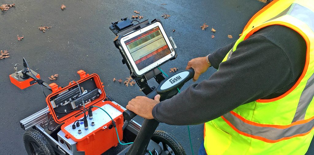
A ground penetrating radar service involves the use of specialized radar equipment to investigate and map subsurface conditions without disturbing the ground.
Professional operators use GPR systems to transmit electromagnetic signals into the ground or through structural materials. When these signals encounter buried objects, changes in soil composition, or hidden structural elements, they reflect back to the receiver. The collected data is then analyzed to identify subsurface features and determine their location and depth.
Unlike traditional excavation or destructive testing methods, GPR allows investigators to gather information quickly while leaving the surface intact.
The result is a safer, more efficient approach to understanding underground conditions before work begins.
Why Subsurface Investigation Matters
Many projects depend on accurate knowledge of what exists below the surface.
Construction crews need to know where utilities are located before excavation. Engineers require information about subsurface conditions when designing infrastructure improvements. Facility managers must understand structural conditions before renovations begin. Environmental consultants often need to identify buried features during site assessments.
Without reliable subsurface information, project teams may encounter unexpected obstacles that affect budgets, schedules, and safety.
Ground penetrating radar services help reduce uncertainty by providing detailed information about hidden conditions before they become costly problems.
Utility Locating and Infrastructure Mapping
One of the most common applications of ground penetrating radar services is utility locating.
Underground infrastructure can include electrical lines, communication cables, fiber optics, water mains, gas pipelines, sewer systems, and drainage networks. Many utilities may not appear on existing drawings or records, particularly in older developments where documentation has changed over time.
Ground penetrating radar helps locate both metallic and non-metallic utilities. Unlike some traditional locating technologies that rely primarily on electrical conductivity, GPR can identify a wide variety of buried infrastructure by detecting differences in material properties.
This capability makes GPR a valuable tool for utility mapping, excavation planning, and damage prevention.
Concrete Scanning and Structural Investigation
Ground penetrating radar services are widely used in concrete scanning applications.
Before cutting, coring, drilling, or modifying concrete structures, contractors need to know what is embedded within the material. Reinforcing steel, post-tension cables, conduits, electrical lines, and voids can all create hazards if they are accidentally damaged during construction activities.
GPR allows technicians to scan concrete slabs, walls, columns, and decks to identify hidden structural components. This information helps contractors avoid costly mistakes while improving worker safety.
Because the process is non-destructive, investigations can be completed without damaging the structure itself.
Supporting Construction Projects
Construction projects often involve significant subsurface uncertainty.
Whether building a new commercial facility, expanding infrastructure, or developing residential property, understanding underground conditions is essential to project success. Hidden utilities, abandoned structures, underground storage tanks, and soil anomalies can all affect construction plans.
Ground penetrating radar services provide valuable information during the planning phase, helping project teams identify potential conflicts before excavation begins.
By reducing surprises and improving site knowledge, GPR helps contractors maintain schedules, control costs, and improve overall project efficiency.
Environmental and Geotechnical Applications
Ground penetrating radar also plays an important role in environmental and geotechnical investigations.
Environmental professionals use GPR to identify underground storage tanks, buried waste, contamination-related features, and subsurface disturbances. The technology can support environmental assessments by providing information about conditions that may require further investigation.
Geotechnical professionals use radar surveys to evaluate subsurface layers, identify voids, locate sinkhole activity, and investigate soil conditions. These insights support safer and more informed engineering decisions.
The ability to gather information without excavation makes GPR particularly valuable for environmentally sensitive sites.
Archaeological and Historical Site Investigations
Ground penetrating radar has become a widely accepted tool in archaeology and cultural resource management.
Researchers use GPR surveys to locate buried structures, graves, foundations, roads, and other archaeological features without disturbing the site. This non-invasive approach helps preserve valuable cultural resources while providing important information about historical landscapes.
By identifying areas of interest before excavation begins, archaeologists can focus their efforts more effectively and minimize unnecessary disturbance.
Ground penetrating radar service has contributed to significant discoveries at archaeological sites around the world.
Advantages of Professional GPR Services
Ground penetrating radar offers several advantages compared to traditional investigation methods.
One of the most important benefits is its non-destructive nature. Surveys can be completed without excavation, drilling, or surface disruption. This reduces costs while preserving existing infrastructure and site conditions.
GPR is also highly versatile. It can be used on soil, asphalt, concrete, pavement, and other surfaces across a wide range of project types.
The technology provides real-time data collection, allowing operators to identify subsurface features as surveys are performed. This immediate feedback helps improve efficiency and supports faster decision-making.
Additionally, GPR can detect both conductive and non-conductive materials, making it valuable for locating a broader range of underground features than some alternative technologies.
Understanding Survey Limitations
While ground penetrating radar is a powerful investigation tool, its effectiveness depends on site conditions.
Soil composition can influence radar penetration depth and image clarity. Highly conductive soils containing significant moisture or clay content may reduce performance compared to dry sandy soils.
Complex underground environments can also create challenging interpretation conditions. Multiple utilities, varying soil layers, and dense infrastructure may require experienced analysis to accurately interpret collected data.
Professional operators understand these limitations and use appropriate survey methods to maximize data quality and reliability.
Data Collection and Reporting
Modern ground penetrating radar services provide much more than field observations.
Advanced software allows collected radar data to be processed, analyzed, and transformed into useful project deliverables. Utility maps, marked site plans, CAD files, GIS data, and three-dimensional visualizations can all be generated from survey results.
These deliverables help project teams integrate subsurface information into planning, design, and construction workflows.
Accurate reporting ensures that valuable survey data remains useful long after fieldwork has been completed.
Choosing the Right Ground Penetrating Radar Service
Not all projects have the same requirements. Utility locating, concrete scanning, environmental assessments, archaeological investigations, and geotechnical studies each present unique challenges.
The most effective ground penetrating radar service combines quality equipment, experienced operators, and advanced data interpretation capabilities. Proper survey planning and accurate analysis are just as important as the technology itself.
By selecting a professional GPR service provider, organizations can gain the reliable subsurface information needed to make informed decisions and reduce project risk.
The Value of Ground Penetrating Radar Services
As construction, infrastructure, and environmental projects become increasingly complex, understanding subsurface conditions has never been more important. Ground penetrating radar services provide a safe, efficient, and non-invasive method for investigating what lies beneath the surface.
Whether locating utilities, scanning concrete, supporting archaeological research, or evaluating environmental conditions, GPR delivers valuable information that improves planning and reduces uncertainty. By helping organizations identify hidden features before excavation or construction begins, ground penetrating radar services contribute to safer worksites, more efficient projects, and better long-term outcomes.
For professionals who need accurate subsurface data, GPR remains one of the most effective tools available for seeing beyond the surface and making smarter decisions underground.
